Exploring the Appalachian Mountains on a World Map
Stretching across the eastern United States like a green spine of ancient ridges, the Appalachian Mountains are one of North America’s most iconic and ecologically diverse mountain ranges. With a geological history dating back hundreds of millions of years, the Appalachians offer more than just breathtaking landscapes—they are home to rich biodiversity, historic trails, and one of the most revered long-distance hiking routes in the world: the Appalachian Trail.
This blog will walk you through exactly where the Appalachian Mountains are on a world map, explain why this mountain system matters on a global scale, and introduce you to the Appalachian Trail Map by Sander Maps—a beautifully crafted visual guide perfect for planning your hike or adding inspiration to your home.

Where Are the Appalachian Mountains on a World Map?
On a world map, the Appalachian Mountains are located in the eastern part of North America, primarily within the United States and stretching into southeastern Canada. Though not as towering as the Rockies or Andes, the Appalachians are one of the oldest mountain chains in the world and were once as tall as the Himalayas.
🌍 Coordinates and Geography
Continent: North America
Countries: United States & Canada
Start (North): Newfoundland and Labrador, Canada
End (South): Central Alabama, United States
Range Length: Approximately 1,500 miles (2,400 km)
When you zoom into a world map, you can trace the Appalachians from eastern Canada, through New England, down through the Mid-Atlantic, and into the southeastern U.S. They pass through 13 U.S. states, including:
Maine
New Hampshire
Vermont
Massachusetts
Connecticut
New York
New Jersey
Pennsylvania
Maryland
West Virginia
Virginia
Tennessee
North Carolina
Georgia
Alabama
While most global mountain ranges are found near tectonic boundaries, the Appalachians are different. They are an ancient, eroded chain formed from continental collisions long before the Atlantic Ocean even existed.
The Appalachian Trail: A Path Through Time and Terrain
Winding along the crest of the Appalachian Mountains is the legendary Appalachian Trail (AT)—a continuous hiking path stretching over 2,190 miles from Springer Mountain in Georgia to Mount Katahdin in Maine.
It crosses through 14 U.S. states, traverses 8 national forests, and connects countless small towns, shelters, and scenic overlooks. Whether you’re thru-hiking the entire trail or enjoying day hikes in your home state, the AT offers a powerful connection to nature and the long, slow rhythm of the mountains.
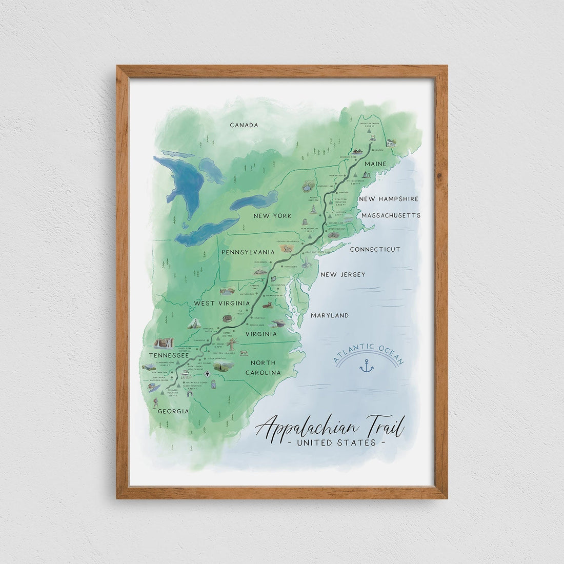
Why the Appalachian Trail Map by Sander Maps Is the Best Way to Explore the Trail
With so many miles of wilderness to explore, having a reliable and visually engaging reference is key. The Appalachian Trail Map by Sander Maps is more than just a navigational aid—it’s a piece of artwork, a planning tool, and a celebration of the trail’s enduring spirit.
🗺️ See the Trail in Its Full Context
This map beautifully displays the entire Appalachian Trail as it weaves through the mountainous eastern U.S. In contrast to typical trail maps that focus on small sections, this full-length view lets you understand how the trail relates to:
Major mountain ranges and national parks
Regional cities and geographic landmarks
State boundaries and forest regions
The design allows you to see exactly where the Appalachian Mountains lie on the North American landscape, making it much easier to appreciate the trail’s scale when compared to a global view.
🎨 A Work of Art for Any Hiker’s Home
One of the standout qualities of the Sander Maps design is its aesthetic beauty. The map features a minimalist yet warm color palette, custom topographical detailing, and thoughtful typography. It’s the kind of map that draws the eye, sparks stories, and looks stunning framed on a wall.
Whether you’re a seasoned thru-hiker or someone who dreams of stepping onto the trail one day, this map makes a perfect focal piece for a living room, study, cabin, or office.
🧭 Designed for Planning and Reflection
The map is not just for display—it’s a functional tool. You can:
Trace the trail through each state
Mark the sections you’ve hiked
Plan future treks or section hikes
Inspire your next journey with a daily visual reminder
It becomes a living record of your experience and ambitions, connecting memory to geography in a meaningful way.
Why the Appalachian Mountains Matter Globally
Seeing the Appalachian Mountains on a world map reminds us of their broader geological and ecological significance.
Ancient Origins: The Appalachians formed during the Ordovician period over 450 million years ago, making them older than the Rockies, Alps, and Himalayas.
Biodiversity Hotspot: The region hosts thousands of plant and animal species, some found nowhere else on Earth.
Cultural Importance: The Appalachians have inspired generations of music, folklore, and literature, from bluegrass ballads to Thoreau’s meditations on nature.
Their presence on the world stage might seem subtle at first glance, but their influence is profound, both ecologically and culturally.

A Map That Inspires Every Step
The Appalachian Mountains are easy to overlook on a world map, but once you trace their long, sinuous line down the eastern U.S., their story becomes unforgettable. Whether you're navigating the winding ridge lines in real life or tracing your journey at home, having the right map brings the trail closer.
The Appalachian Trail Map by Sander Maps gives hikers, travelers, and lovers of the outdoors a way to stay connected to one of the world’s most meaningful mountain journeys. It's both a visual compass and a piece of your hiking soul.