Grand Canyon Trail Map Rim to Rim, Inspiration and Guidance
The Grand Canyon is one of the most awe-inspiring landscapes on Earth—an immense, colorful chasm carved by time and water, steeped in geological and human history. For hikers and explorers, walking rim to rim across this natural wonder is not just an outdoor challenge but a personal rite of passage. It's a test of endurance, a deep connection to the rawness of the Earth, and an experience that stays with you long after the last step.
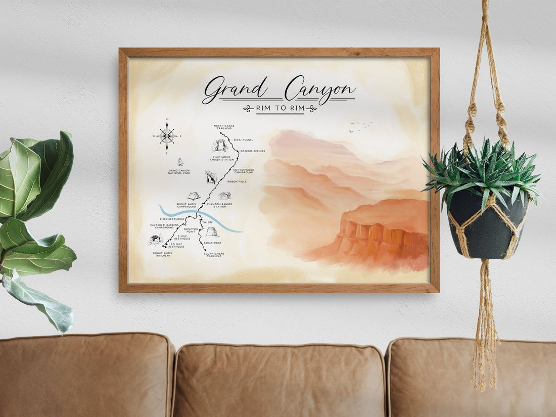
For those planning the journey or celebrating a successful crossing, the Grand Canyon trail map rim to rim by Sander Maps offers both a powerful planning tool and a meaningful piece of wall art. It’s a way to visualize the route, inspire action, and reflect on the grandeur of one of the greatest hiking experiences in the American Southwest.

The Importance of the Grand Canyon in American History
Long before modern adventurers began their treks across the Grand Canyon, this incredible geological formation had already captivated explorers, scientists, and Indigenous cultures for centuries. The Grand Canyon stretches 277 miles across northern Arizona, revealing nearly two billion years of Earth’s history layer by layer.
For the Havasupai, Hopi, Zuni, Hualapai, and other Indigenous communities, the Grand Canyon has always been more than a destination. It is sacred ground, a living landscape filled with stories, meaning, and spiritual presence.
In the late 1800s and early 1900s, Western explorers such as John Wesley Powell brought the Grand Canyon into broader public awareness. Powell’s daring river expedition through the Colorado River in 1869 helped map the uncharted gorge and brought scientific attention to the canyon’s geology and natural history.
Today, the Grand Canyon is not only a UNESCO World Heritage Site but a powerful symbol of the American wilderness experience. Hiking rim to rim taps directly into that legacy, blending personal accomplishment with a connection to one of nature’s most profound creations.

The Rim to Rim Experience: A Hiker’s Journey Through Time and Terrain
Hiking from one rim of the Grand Canyon to the other is considered one of the most rewarding long-distance day hikes or multi-day backpacking routes in the United States. Whether starting at the North Rim and ending at the South Rim or going in reverse, the journey spans roughly 21 to 24 miles depending on the route, with thousands of feet of elevation loss and gain.
Along the way, hikers experience extreme elevation shifts, stunning canyon views, and encounters with the desert’s diverse ecosystem. Routes typically follow trails such as the North Kaibab Trail, Bright Angel Trail, or South Kaibab Trail, depending on logistics, weather, and trail conditions.
Completing the rim to rim hike requires thoughtful preparation, physical training, and an understanding of the route. This is where a Grand Canyon trail map rim to rim becomes a vital part of both the journey and the story you tell afterward.
Why the Grand Canyon Trail Map Rim to Rim by Sander Maps Is So Inspiring
Maps are more than tools—they’re visual stories. The rim to rim trail map by Sander Maps captures the full scope of the Grand Canyon’s majesty in a clean, modern format that appeals to hikers, artists, and outdoor lovers alike.
This map is not only a guide to the path across the canyon but a celebration of the achievement itself. It combines accurate trail representation with an elegant design that turns topography into art.
When displayed in your home, this map becomes a reminder of what you’ve accomplished or a source of motivation for what lies ahead. Whether you’re preparing for your first crossing or commemorating a hike that changed your life, the map brings the experience into view every day.
The Experience of Being a Hiker in Arizona
Arizona is a hiker’s paradise. From the high plateaus of Flagstaff to the Sonoran Desert trails of Tucson, and especially the vast expanse of the Grand Canyon, the state offers endless opportunity for outdoor exploration. To hike rim to rim is to experience Arizona in its rawest, most humbling form.
The extreme elevation, arid heat, and changing terrain demand resilience, patience, and respect for the environment. Hiking in Arizona teaches you to listen to your body, pace yourself, and move with intention. Few places test and reward a hiker like the Grand Canyon.
Having the Grand Canyon trail map rim to rim by Sander Maps in your home connects you to that lifestyle. It’s a personal badge of your love for hiking in the Southwest and a tribute to the journey you’ve embraced—whether you're still training for it or proudly looking back on your crossing.

How the Sander Maps Rim to Rim Trail Map Guides the Journey
The value of the map extends beyond its beauty. It is a helpful companion for understanding the complexity and grandeur of the canyon’s trails. This detailed map includes:
A clear depiction of the North Kaibab, South Kaibab, and Bright Angel Trails, showing the entire journey from rim to rim Elevation changes that help you anticipate the steep descents and strenuous climbs
Waypoints such as Phantom Ranch, Cottonwood Campground, and the Colorado River, giving context to your progress A layout that allows you to visualize water sources, trail intersections, and resting spots
By seeing the route from a bird’s-eye perspective, hikers can better understand the timing and logistics of the trip. It aids in training, helps build a mental model of the trek, and supports smarter decisions on the trail.
For those who have already completed the hike, the map becomes a visual retelling of every step taken across the canyon floor.

Let the Trail Map Tell Your Story
Crossing the Grand Canyon rim to rim is an unforgettable achievement. It’s a journey that pushes your body, opens your mind, and grounds you in the natural beauty and scale of the Earth. It is one of those rare adventures that transforms you.
The Grand Canyon trail map rim to rim by Sander Maps turns that transformation into something you can see and touch. It’s not only a stunning addition to your space but a personal reflection of your passion for the outdoors and your appreciation of this historic, majestic place.
Whether you're mapping your way to the trailhead or reflecting on the moment you reached the other rim, this map helps you hold onto the wonder of the canyon—every day.